Hey all, we moved to Kellogg from Montana this past year and are trying to get our bearings. We don't have a sled (yet) and we ski backcountry quite a bit throughout our typical winter. My question is, without a snow machine, where should we be looking? I've been up around West Willow a few times, but we could still drive to the trail head. Trying to get an idea of how far we can drive/where we are going to end up parking for the different areas around the Silver Valley. Any insight will be greatly appreciated. Thanks! -Russ
Sledless access, Silver Valley
- Thread starter Russ
- Start date
Hey Russ. I’m in the same boat. Moved to Kellogg a litter over a year ago, and still trying to find easy access touring. Like you I’ve been up to West Willow, but mostly just focused on side country at Silver. However, tomorrow a buddy and I are going to check out the terrain around Burke. Likely going to try Tiger Peak, Rabbit Gulch or Glidden Lake area. Let me know if you want to join.
Hi. Id be interested in touring W willow area on Monday, Jan 20. Experienced in the BC but have not been up to this zone yet. Let me know, thanks.Hey Russ. I’m in the same boat. Moved to Kellogg a litter over a year ago, and still trying to find easy access touring. Like you I’ve been up to West Willow, but mostly just focused on side country at Silver. However, tomorrow a buddy and I are going to check out the terrain around Burke. Likely going to try Tiger Peak, Rabbit Gulch or Glidden Lake area. Let me know if you want to join.
St. Regis and the N. side of I-90 at Lookout pass are about it besides above Burke and Willow, plenty of stuff off Silver but the warm up last Wednesday pretty much ruined the terrain until we get a refresh.
I Tele at Silver and have done most of the available terrain, so if you see a telemarker in black ask and I'll share.
I Tele at Silver and have done most of the available terrain, so if you see a telemarker in black ask and I'll share.
PowderPanda
Staff member
Glidden Lake is an insane long haul without a sled.. I only know a few people that have done it. When accessing Tiger, just don't have your radio n cranked when getting ready thereat the side of the road, the guy that lives in the house up there get's a bit testy over that. Just be a good neighbor.
Rabbit Gulch is a nice little one that is a 2 mile climb in, pretty easy. No real avy danger with it either. Mostly 20-25degree slope. Just dont go east over the ridge without proper knowledge.
Also, St Regis Basin (south) behind Lookout Pass has great terrain, 2 mile walk in before you climb though. Also, very much avy savy needs there. Route finding for the climb and ensuring a full review of IPAC avy conditions.
With the fact we've had no new snow and much of it is East facing, the slopes are probably cooked.
Cheers!
PP
@PowderPanda new to the area! do you have directions to access rabbit gulch? thank youGlidden Lake is an insane long haul without a sled.. I only know a few people that have done it. When accessing Tiger, just don't have your radio n cranked when getting ready thereat the side of the road, the guy that lives in the house up there get's a bit testy over that. Just be a good neighbor.
Rabbit Gulch is a nice little one that is a 2 mile climb in, pretty easy. No real avy danger with it either. Mostly 20-25degree slope. Just dont go east over the ridge without proper knowledge.
Also, St Regis Basin (south) behind Lookout Pass has great terrain, 2 mile walk in before you climb though. Also, very much avy savy needs there. Route finding for the climb and ensuring a full review of IPAC avy conditions.
With the fact we've had no new snow and much of it is East facing, the slopes are probably cooked.
Cheers!
PP
")
I don’t know how to post tracks here, but you drive from Wallace ID up to the minning town of Burke. Go east through the town and continue until you arrive at the substation parking lot. Park your vehicle and skin from the lot straight east on the groomed snowmobile road for about a mile. Right after you cross the small bridge, turn left on to the open area under the power lines. The skin track starts from there.
Thanks Mike! have you been out there in the last few days? skiable? thanks in advance.I don’t know how to post tracks here, but you drive from Wallace ID up to the minning town of Burke. Go east through the town and continue until you arrive at the substation parking lot. Park your vehicle and skin from the lot straight east on the groomed snowmobile road for about a mile. Right after you cross the small bridge, turn left on to the open area under the power lines. The skin track starts from there.
PowderPanda
Staff member
@aparagusgirl,
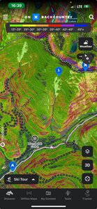
Sorry form the delay. Last exit for Wallace, turn left up the Burke Canyon for about 15 miles (careful of the dogs in the small towns.. LoL), drive to the sled parking area (noted with a sled below). From there, two choices, one is up the sled road to the first bridge, go left and fallow the logging road.
One can also go rom the NE side of the parking/sled lot there's a sled road that heads into the trees, go through there, acorss the creek and stay on the North side of the creek as it heads up toward the forest/logging road that gets into the the zone.
If you have a mapping app, it would be good to use to get in there. The distance in is right about 2 miles to the bottom of the shale slide. The climb up is pretty easy.. especially up the slope itself. No avy danger on the slope itself.. but you can see the access through the gulch has some steep spots, so just. keep your attention as you travel through that area.
It's been awhile since I've been in there, I think the logging road now goes right close to the area.
I'll also note, anything over the ridge to the N/NE from Rabbit Gulch is very avalanche prone area, needing really good route finding.. albeit some insane good riding (my track for that area was prior to using OnX).
Cheers!!
PP
I was up there on Tuesday. The tree bombs had wrecked the glades - it was difficult even on the skin up. The open areas still had some good skiing, but there were a lot of snow bike tracks that needed to be avoided.